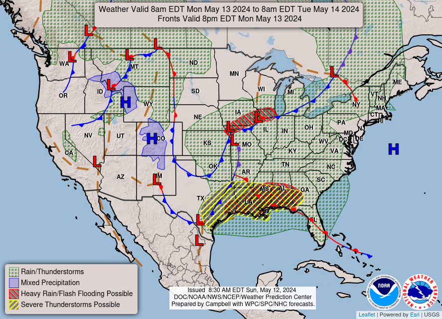
…Risk for numerous instances of flash flooding will shift from eastern
Texas/central Louisiana late Sunday to the central Gulf Coast Monday…
…Showers and storms expected ahead of a cold front across the Central
Plains into the Mississippi Valley Monday, spreading into the Ohio Valley
and Interior Northeast by Tuesday…
…Generally above average temperatures expected for the West…
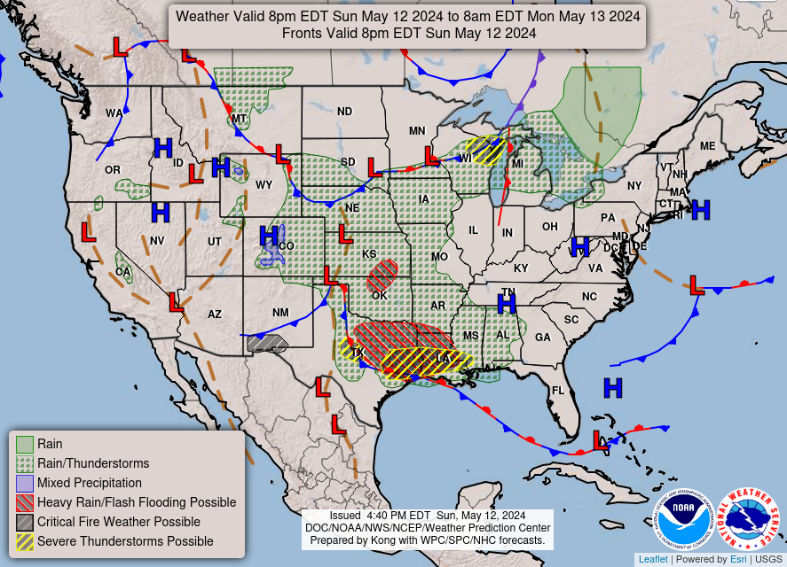
A southern stream upper-level wave and associated surface frontal system
traversing the south-central U.S. this weekend/early next week will
continue to bring extremely heavy rainfall and the threat for flash
flooding, as well as severe weather, from the Southern Plains to the
Southeast. The threat Sunday evening into early Monday morning will be
focused on portions of eastern Texas into central Louisiana where a
Moderate Risk of Excessive Rainfall (level 3/4) remains in place. Here,
abundant moisture and strong CAPE will lead to very heavy downpours with
additional rounds of storms focusing along a slow moving warm front
leading to several inches of rain on top of wet antecedent conditions.
Scattered to numerous instances of flash flooding remain possible
overnight Sunday. The system will continue eastward Monday, with the
threat of very to extremely heavy rainfall extending along the warm front
through the central Gulf Coast. A Slight Risk of Excessive Rainfall (level
2/4) stretches from eastern Texas to the Florida Panhandle, with a more
concentrated Moderate Risk centered on southeastern Louisiana to the far
western Florida Panhandle where the greatest confidence in coverage of
repeated storms producing intense downpours exist. The prospect of several
inches of rain could lead to numerous additional instances of flash
flooding Monday. Additionally, storms will also have the potential to
become severe, with a Slight Risk of severe weather from the Storm
Prediction Center stretching from central Texas to southwest Georgia and
the Florida Panhandle for the threat of very large hail, damaging winds,
and a few tornadoes. The warm front will begin to lift further
northeastward on Tuesday, with showers and storms extending towards the
Atlantic coast of the Carolinas and Georgia. Another Slight Risk of
Excessive Rainfall exists across this region southwestward through the
Florida Panhandle where a few additional scattered instances of flash
flooding will be possible.
Another frontal system to the north will bring additional showers and
thunderstorms from the Central Plains late Sunday to portions of the
Mississippi Valley and Midwest by Monday. The most concentrated focus for
storms will be ahead of a southeasterly moving cold front through portions
of the Middle Missouri and Mississippi Valleys. While rain rates wont be
quite as intense as in the South due to a lack of greater moisture and
instability, enough rain is still expected to lead to some threat for
flash flooding, with a Slight Risk of Excessive Rainfall in place. Shower
and storm chances will spread eastward ahead of the cold front into the
Great Lakes/Ohio Valley by Monday evening and into the
Appalachians/Interior Northeast into the day Tuesday. To the west, the
next system dropping southeastward from western Canada will begin to
spread into the Northern Rockies/Plains late Monday and into the day
Tuesday, bringing a chance for some light to moderate showers and
thunderstorms. Some snow will be possible for higher elevations into the
mountains.
Forecast temperatures will tend to be near or a bit below average for
eastern portions of the country under the influence of the active pattern.
Highs Monday and Tuesday generally range in the 60s and 70s from the
Central Plains east through the Tennessee Valley to the Carolinas and
northward, with more 80s possible from the Southern Plains into the
Southeast. One exception will be south of the warm front along the Gulf
Coast over portions of South Texas and Florida, where highs will be hot
and into the 90s and low 100s. Some record-tying/breaking high
temperatures will be possible. In the West, highs will be well above
average over portions of the Northern Rockies/High Plains Monday, with
temperatures into the upper 70s and low 80s, before the noted frontal
system pushes in and drops temperatures into the 60s Tuesday. Conditions
will also be well above average over central/northern California and the
adjacent Great Basin, with 80s and even some 90s expected inland from the
immediate Pacific Coast. While not as anomalous, temperatures will still
be above average in the Pacific Northwest by Tuesday, with highs into the
70s, as well as in the Desert Southwest, with highs in the 90s to low
100s.
Putnam
Graphics available at
https://www.wpc.ncep.noaa.gov/basicwx/basicwx_ndfd.php


Leave a Reply