Up to an inch of precipitation is possible in central Indiana, mainly east and south of Indianapolis.

The upper air ingredients don't persist with this system eastward, so no severe weather is expected here. https://t.co/KVlQE9zjmz
— Paul Poteet Dot Com 🇺🇸 (@PaulPoteet) April 29, 2024
Our next big weather maker arrives Friday. Again: no severe weather expected…at least for now. Most of the first weekend in May looks dry.
WEEKEND RECAP
Indy made it to 79 Saturday and 81 Sunday. Muncie hit 80 Saturday and 83 Sunday. The high was 77 in Lafayette Saturday with about a quarter of an inch of rain from one storm, and then it reached 79 Sunday.
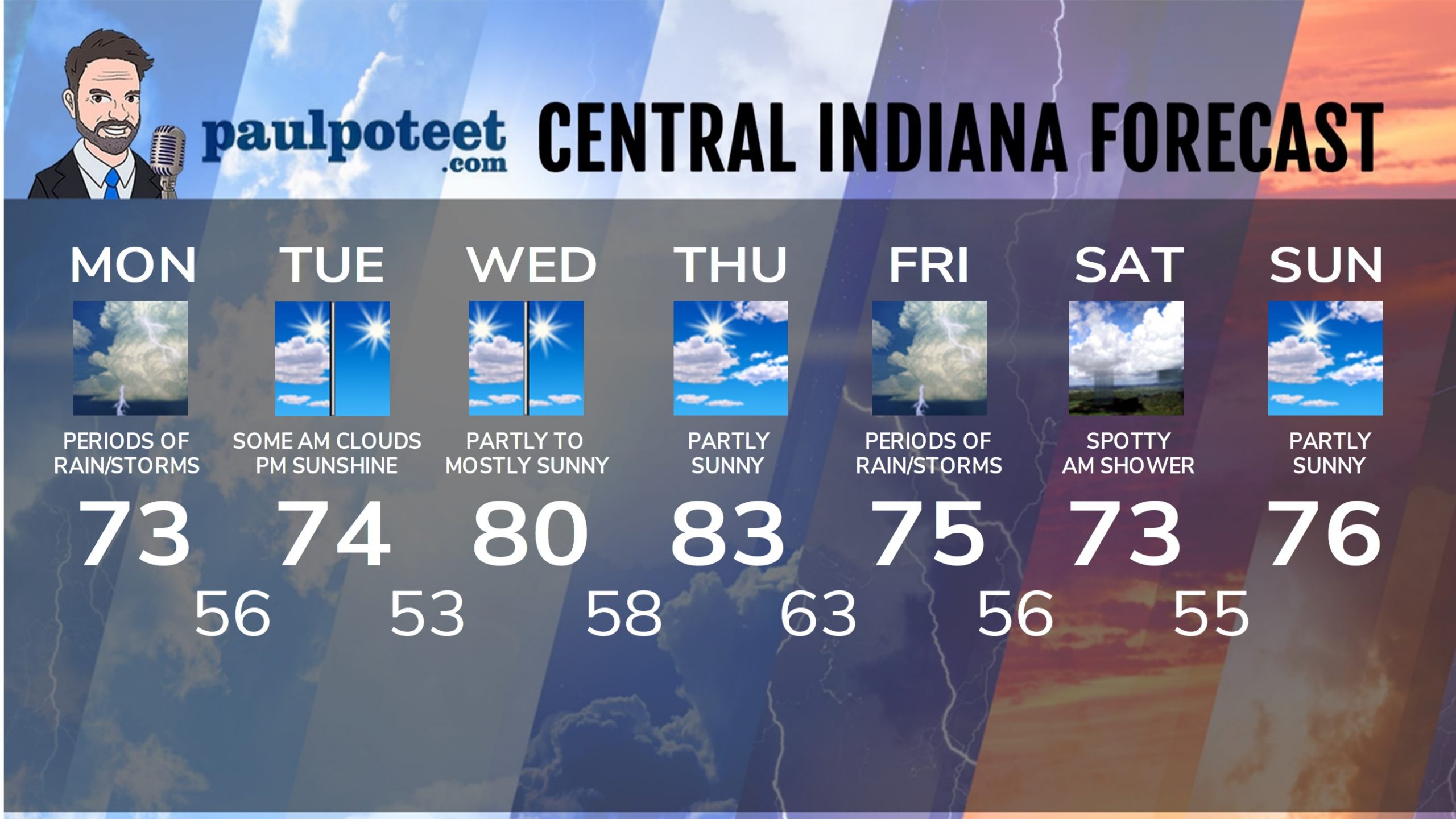
INDY SEVEN DAY FORECAST
Today: Scattered morning showers and storms. Widespread showers and storms in the afternoon. Wind gusts to 30 mph. High 73.
Tonight: Widespread showers and storms in the evening. Showers will diminish overnight. Low 56.
Tuesday: Partly sunny morning. Sunny afternoon. High 74.
Tuesday Night: Clear. Low 53.
Wednesday: Partly to mostly sunny. High 80.
Wednesday Night: Partly cloudy. Low 58.
Thursday: Partly sunny. High 83.
Thursday Night: Partly cloudy. Low 63.
Friday. Scattered showers and storms. High 75.
Friday Night: Scattered showers and storms. Low 56.
Saturday: Spotty morning showers, then partly sunny. High 73.
Saturday Night: Partly cloudy. Low 55.
Sunday: Partly sunny. High 76.


Never miss me! Subscribe for free. My Huge Radar has real-time weather tracking, current temperatures, and severe weather watches and warnings. Get detailed Indiana conditions by clicking here. Click here to see my central Indiana 7-Day Forecast. Follow these links to get my forecasts for Lafayette, Muncie, Hendricks County, and Hamilton County. Need a second opinion? Click here for central Indiana National Weather Service forecasts. (Some charts via WeatherBELL.)


Leave a Reply