
In the shadow of an elevated freeway near Toronto’s Port Lands, a former fish processing plant has been painted cerulean blue and converted into a test lab for a networked urban development project where physical and digital infrastructures will be optimized to support a “people-centered” neighborhood. What that means, exactly, is still being worked out.
For some critics the Quayside project conjures up a surveillant dystopia straight out of Black Mirror, but you wouldn’t know it from a visit to the building at 307 Lake Shore Boulevard East. 1 On Sunday afternoons, the public is invited inside this “experimental work space” to co-create and learn. The vibe is resolutely low tech, sort of underground-arts-venue-meets-elementary-school. Analog media like post-it notes, index cards, and rough architectural models decorate the scaffoldings of plywood, chipboard, and cork. Everything in this 8,000-square-foot, high-ceilinged, primer-white space has been designed to suggest transparency. “The concrete floors have been ground down, but not perfectly polished,” according to a corporate blog post. “The columns, once covered up with drywall, have been stripped to reveal their graffiti-lined steel skeletons.” 2 This is an adaptive space — modular, provisional. It embodies a commitment to messy improvisation. Architect Luc Bouliane sounds almost surprised by his own work: “It actually looks like something that you would be testing a lot of stuff in.” 3
The company doing all that testing is Google; or, rather, Alphabet’s urban innovation unit, Sidewalk Labs, which opened this space in the summer of 2018, about a year after winning the bid to master plan Quayside and a year before releasing the 1,500 page draft. More on that later. What I want you to see now is the showroom where plans are presented to — and workshopped with — the public. It’s filled with exhibits that use the card motif of Google’s Material Design language to explain Sidewalk’s proposals for accessibility, environmental sustainability, social infrastructures, and data use in the reimagined smart city. Humble sawhorse tables host comment cards with feedback from the “co-designers.” (Meaning us.) A stack of blank cards and a pile of markers invites new voices. “A question I have about facial recognition is: ____?” reads one prompt. “How will sensors and cameras be used wrt safety/security in data collection?” comes the response. Nearby, a cardboard apartment — an “efficient unit prototype” — has been marked up with colorful post-it notes. “Corridor too narrow for wheelchairs,” one visitor offers. “I like looking at something while I cook,” reports another. Sidewalk’s team of community liaisons roam around, striking up casually scripted conversations with guests.


All this effort at public engagement makes sense when you understand the controversy that surrounds Waterfront Toronto, an entity set up by the city, provincial, and national governments to redevelop the 12-acre Quayside site into a “globally-significant community that will showcase advanced technologies, building materials, sustainable practices and innovative business models that demonstrate pragmatic solutions toward climate positive urban development.” 4 Critics charge that Sidewalk Labs received unfair advantages in its bid to develop the master plan, and they worry that the city has opened the door for a Big Tech behemoth. Alphabet doesn’t just mean Google Search and Maps. It also means Android, Chrome, YouTube, and AdSense. It means the self-driving cars at Waymo, the smart home products at Nest, the drones at Project Wing, the AI project DeepMind, the biotech group Calico, the life sciences arm Verily, the private equity fund Capital G, and the wind energy company Makani. How will data circulate among these organs? Jesse Shapins, the director of urban design and digital innovation for Sidewalk Labs, told me there’s “no crossover” between his unit and those other entities. 5 Yet Alphabet has the tools to design, build, fund, power, connect, monitor, and monetize a city, and that prospect scares people. 6
Paper and ink, models and maps: these are the accessible tools of civic engagement — and corporate self-defense.
Alarm bells rang last summer when Sidewalk revealed ambitions to scale up from 12 to 190 acres at Quayside. Under political pressure, the company eventually retreated from that position, but critics remain concerned about the opaque terms of this public-private partnership, the reliance on proprietary technologies, and the lack of clarity about data governance. 7 Sidewalk has tried to allay fears with ostentatious displays of transparency, not just in open hours at the 307 workspace, but also in a formal appendix to the master plan, where it commits to “planning for a future where community members can easily influence the decisions, spaces, and technologies that impact them, and where decision-making entities can be even more responsive to community input.” 8 Paper and ink, models and maps: these are the accessible tools of civic engagement — and corporate self-defense.

Sidewalk’s response may seem cynical, but the workshops at 307 invoke a long history of community-led urban design, planning, and mapping — activities sometimes lumped together as civic design or participatory planning. A brief overview might start (at least in the Euro-American context) 9 with Patrick Geddes’s work in turn-of-the-20th-century Scotland. As he developed a regional plan for Edinburgh, Geddes advocated for community involvement, conducted civic surveys, and educated the public through performances and exhibitions like his “Outlook Tower,” which included a camera obscura. From there, we might touch on key moments like the proliferation of social surveys and opinion polls in the 1930s and ’40s, which gave respondents influence over public policy; Jane Jacobs’s revolt against top-down planning in the 1960s, which led to laws mandating community input; and the Brazilian Workers’ Party’s invention of participatory budgeting in the 1980s. 10 Today, it’s common for government agencies and private firms to use maps, models, games, and other playful methods to solicit and validate public spatial knowledge, which supposedly informs their designs. 11 Meanwhile, communities use homegrown methods — radical cartography projects, rogue planning departments, squatters’ collectives, and so on — to counter official plans and create their own designs for spaces that are not official priorities. 12 The democratization of digital mapping tools has enabled more people to model their own worlds: to “hold governments accountable … fill gaps when infrastructural and municipal services are fragmented … [and] make visible social and political processes and events that might be otherwise hidden or overlooked.” 13
In official settings, “public affairs specialists” and “community engagement consultants” are sometimes hired to meet statutory requirements. (Sidewalk Labs, for example, tapped the Canadian firm MASS LBP, a “pioneer of innovative democratic processes.”) 14 These specialists bring skills and sensibilities that are rarely taught in urban design schools, and that perhaps shouldn’t be expected of designers, given the methodological expertise and cultural sensitivity this work requires.15 Yet by mandating public participation and outsourcing it to consultants, governments run the risk of transforming community relationship-building into a checklist of codified practices. “The community” invited to participate has reason to be skeptical, especially when the invitation comes from a commercial developer with money to gain and data to harvest. To quote the wisdom of student insurgents in 1968: “I Participate, You Participate, He Participates, We Participate, You All Participate, They Profit.”

As cities turn to outside contractors to manage urban infrastructures and development projects, they often get locked into inscrutable private platforms. Civic design tools such as participatory maps and community engagement apps help keep urban data and oversight powers in public hands. Yet those same tools can be co-opted by savvy tech developers who have mastered the techniques of discursive engineering. “Participation” is now deployed as part of a public performance wherein the aesthetics of collaboration signify democratic process, without always providing the real thing. A disingenuous use of maps, apps, and other tools of participatory planning — call it mapwashing — threatens to undermine the democratizing, even radical potential of civic design.
The old tools of participatory design, like the survey and the map, have little value where automated data extraction feeds directly into algorithmic urban engineering.
Against this backdrop, the very meaning of “participation” is changing. 16 Many of us live in a world of ubiquitous surveillance, haloed by a swarm of satellites, pinned in by huge repositories of proprietary geodata, tracked by devices that constantly ping our locations to sentinels in the cloud. The old tools of participatory design, like the survey and the map, have little value where automated data extraction feeds directly into algorithmic urban engineering. If urban design can be automated, if cities can be made responsive to real-time data collected from environments and inhabitants without their explicit consent, how meaningful is our participation? Sidewalk Toronto should prompt reflection about the ethics of conscripting urban subjects as passive participants in smart-city design. 17

The Civic Lab as Participatory Map
Amidst all the analog accoutrements at the 307 showroom, there are a few screens where visitors can watch videos, zoom in on interactive maps, and fiddle with Sidewalk’s bespoke design tools. One tool, which earns its own kiosk, is CommonSpace, an application for conducting “public life studies.” For decades, researchers inspired by urbanist Jan Gehl have conducted empirical studies using clipboards and clickers to record how people use parks, plazas, and other public spaces. With CommonSpace, they can input data directly into an app built on Gehl Institute’s Public Life Data Protocol, an open standard meant to allow for easier site comparison, visualization, and analysis, so that designers can make “evidence-based, human-centered” decisions. 18 Sidewalk Labs engineer Ananta Pandey reports that the team experimented with high-tech data collection, including cameras and computer vision, but ultimately opted for “in-person approaches” informed by Gehl’s humanist perspective, because “when community members participate, they not only add important local context but subsequently tend to become more active participants in the planning process.” 19
The humble materials — concrete, chipboard, foam blocks — are rhetorical tools suggesting that, here, cities are ‘workshopped.’
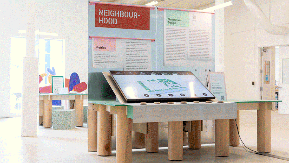
That belief is reflected at 307 in the installation of “colorful, rolling, modular, stackable, playful interactive tools,” which generate “input + discussion + experimentation + new ideas + action,” according to exhibit designers Daily tous les jours. 20 Among the furnishings is a low, mint-green table where visitors can interact with a generative map of a virtual neighborhood, turning large wooden knobs to alter building shape, height variation, density, the street grid, and the distribution of green space. With those parameters set, mapmakers can give feedback by pushing a happy- or sad-face button. The childlike interface “warms up” the cold screen, transforming a sophisticated planning tool into a SimCity-like game, which DTLJ says will “raise the levels of literacy” about planning and design, and foster better conversations among policymakers, urbanists, and the general public. 21 It’s hard to argue with that. But in this setting the interface disguises the real-world ramifications of a tool that promises to use “machine learning and computational design” to “generate not just one or two but millions of comprehensive planning scenarios” and evaluate impacts on “key quality-of-life measures” — a tool that will “get smarter as time goes on.” 22 Let’s hope some of those conversations include critical reflection on whose “quality of life” we’re optimizing for, and how generative design can be misused.

“Small data” are harvested throughout 307’s common space in the form of ubiquitous comment cards. 23 And the space itself is a platform for Sidewalk researchers to observe public behavior, conduct informal interviews, pull together focus groups, pilot-test new urban features, collect performance data, and iterate. The responsive street pavers and building canopies and mock-up kitchens tested at 307 may ultimately find their way into actual streets and apartments. And the humble materials — concrete, chipboard, foam blocks — are rhetorical tools suggesting that, here, cities are “workshopped.” Urban futures and data plans are co-created from a mix of open platforms and public knowledge. 307, you might say, is a participatory map writ large. In recent months, Sidewalk Labs has installed a large-scale model of the proposed development, complete with wood buildings that demonstrate the use of tall timber construction and small video screens that show “a day in the life” of future Quayside.
Eventually, the workspace will be turned inside out, so that the neighborhood becomes the laboratory and the map.
Eventually, the workspace will be turned inside out, so that the neighborhood becomes the laboratory and the map. In the draft Master Innovation and Development Plan, released last June, Sidewalk describes its intention to create a “high-resolution, 3D, comprehensive digital map of the public realm,” which would serve as a “single repository for information about open spaces and related infrastructure, creating a shared foundation for ongoing operations and proactive maintenance.” 24 This miraculous map, updated continuously via data collected by sensors, personal devices, and “open-space managers,” would include public spaces, from parks to public libraries; amenities and physical infrastructures, from benches to playground equipment; utility systems, such as stormwater pipes and power grids; “shared participatory infrastructure,” like electrical outlets, public speakers, water fountains, Wi-Fi, and picnic tables; and technology that projects information and artwork on city surfaces. That system would, in turn, “scale out” as an urban prototype for implementation in cities around the world.

Who are the participants here? A map compiled in real time — its points and lines constantly refreshed, based on the live location of moving subjects — would rely on the passive reports of objects and human monitors. And however much Sidewalk’s team likes to talk about the “active participation” of “co-designers,” there will be limits on the agency those humans have. You can see those limits already at the 307 workspace. Perched high in one corner are a white cylinder and gray box containing a Numina sensor. A nearby sign uses stencil and san-serif fonts to communicate friendliness and informality. “Hello,” it says. “A low-resolution image of you may be taken in this area. This image is immediately de-identified and is only used to calibrate and validate pedestrian and vehicle movement operating in the area.” No opt-in or out. No solicitation of the visitor’s opinion or request for consent. Numina simply is, as-is, and it can take your photo and map your location before you know it’s there. Public “participation” consists of an unwitting provision of data and a quick education in the surveillant tech that will pervade our future cities, if we let it. 25

Too-Much-Ness
The 307 workspace is not the first Sidewalk Labs office I’ve toured as a student of mediated cities. I’ve also been to the company’s headquarters, at Hudson Yards, the luxury development in New York City that I previewed for Places in 2016, in an article that traced the historical and ideological ties between Sidewalk CEO Daniel Doctoroff and the remaking of Manhattan’s west side. 26 Sidewalk Labs provided digital master-planning support for the Hudson Yards developers — Related and Oxford Properties — and was one of the first tenants. As Matt Shaw explained in The Architect’s Newspaper, because the development is on state-owned land, “there was no oversight from community boards … leaving the citizens of New York City more-or-less out of the conversation.” 27 Minimal design review and public process meant that the map could be redrawn with little regard for what or who gets erased. Related is not the type of company to collect public feedback on colorful comment cards. 28
Sidewalk Labs’s Jesse Shapins says he welcomes the opportunity to envision a ‘smart city that’s not driven by techno-solutionism.’
In Toronto, Sidewalk Labs has taken a different tack, cultivating a brand very much unlike Related’s. Here it’s all about process and documentation. Many people on the team have deep backgrounds in public service and civic design, and Shapins says he welcomes the opportunity to envision a “smart city that’s not driven by techno-solutionism.” 29 The engineers and planners understand that they operate in a post-Cambridge Analytica world, subject to scrutiny by a public that distrusts “big tech.” Their design process is documented extensively on the company’s website and its Medium channel “Sidewalk Talk,” launched in November 2016, “where technologists and urbanists discuss the future of cities.” All that public-facing work lets us appreciate the evolving rhetoric around the project.
As designer and critic Kevin Rogan has noted, the first wave of Sidewalk Toronto images, accompanying the 2017 proposal, were rendered in SketchUp but meant to look hand-drawn. The calculatedly organic design conveys a humanist ethic and suggests that these are works-in-progress, mere imaginings subject to public input. Yet even in this human-centered terrain, the illustrated people have no faces, the trees no individual leaves. Maybe those details are yet to be determined, or maybe we’re meant to imagine ourselves inhabiting those anonymous bodies. As media scholar M. L. Sauter observed, the illustrations are diagrammatic and didactic, “reminiscent of the complex cutaways in children’s books like David [Macaulay’s] The Way Things Work or Stephen Biesty’s Incredible Cross Sections.” Rudimentary line drawings of Toronto fixtures and furnishings, from signature sites like CN Tower to generic objects like a lost mitten, imply that Sidewalk is capable of appreciating the little things that make the city both unique and universal. 30


Released two years later, the company’s four-volume, 1,500-page Master Innovation and Development Plan, designed by Pentagram, features an encyclopedic range of graphic styles: elementary Richard-Scarry-like drawings, photorealistic renderings, dramatic portraiture, abstracted maps, data visualizations, and a barrage of those flat graphics so common in app and startup interfaces, which deploy “cheerful minimalism to mask the insidiousness of multinational tech corporations with friendliness and approachability,” as Rachel Hawley puts it. 31
Each visual mode makes a different epistemological claim: this is definite, while that has yet to be determined; this is speculative, while that is empirical.
Each visual mode makes a different epistemological claim: this is definite, while that has yet to be determined; this is speculative, while that is empirical. The content is similarly varied: facts and figures, flows and feelings are all in the mix. Photographs, often black-and-white or monotone, portray barren landscapes along the Toronto waterfront, just begging for remediation, or dynamic spaces elsewhere that can serve as inspiration. Axonometric drawings propose mixed-use spaces or demonstrate new technologies, like sensor-infused streetscapes and modular building parts. Maps show the interconnection of smart urban systems. Parks get the Richard Scarry treatment, but the flat, cheerful graphics of Big Tech are used to show families growing into, and evolving with, their homes. In one scene, a family with a newborn extends its apartment into the next-door unit, while a worker adds a faux-wood finish to the molding around the cased opening. A new doorway is thus granted the semblance of load-bearing structural integrity, suggesting that the potential for organic growth is a foundational principle. 32


Predictably, the renderings caused a stir on Twitter. “There’s almost TOO MUCH 21st-century urbanism,” said design critic Alexandra Lange. “Kites! Kayaks! Heatherwick balconies! Leftover industrial equipment painted cunning colors! Permeable pavements!” 33 Urban trends from the last two decades piled up like a bike messenger crashing into a street juggler. There were co-working spaces and craft breweries and resistance-band fitness classes and dogs in sweaters. The too-much-ness of Sidewalk Labs — the workshops and maps, the exhaustive archive and open-source code, the comment cards and “care collectives” (which provide health and well-being services, and conveniently allude to an anti-capitalist organizational form) — adds up to a form of “engagement theater,” says Bianca Wiley, one of the most vocal critics of the Toronto project. 34
The too-much-ness of Sidewalk Labs adds up to a form of ‘engagement theater,’ says critic Bianca Wiley.
Another critic, Nabeel Ahmed, laments that despite Sidewalk’s promise of “openness … collaboration and co-creation,” despite all the roundtables and meetings and reports, despite all the activity at 307 and the enumeration of ways in which public feedback has informed the design, the company ultimately “pushed forward its own agenda.” Ahmed claims that by emphasizing popular amenities like parks, and creating apps to help the public understand them, Sidewalk has diverted attention from thornier problems like data governance. “Already-fleshed-out ideas” are presented “with little room for debate, leaving conversations with residents to be a largely performative exercise.” 35 Wiley faults the company for hiding plans to scale up to 190 acres. “If Sidewalk would have started to show maps of the entire Port Lands, from day one, and tied their intents and influence to that scope more broadly,” she said, “some people would have had a very different reaction.” 36

Sidewalk is also using its showroom to test-drive potential investments. When I visited 307 last year, I saw (but was not allowed to play with) a demo of “digital electricity,” which promises to be a more efficient, “packet-based” alternative to standard AC/DC. Later, I learned that Sidewalk had made a major investment in VoltServer, the startup behind the technology. 37 And while the kiosks and public forums get attention for showing the merits of tall timber construction and modular pavers, behind the scenes Sidewalk Labs has been developing new technologies to automate and script collaboration and participation. These programs deserve scrutiny for their potential to change the relation between cities and the people who live in them.
Behind the scenes, Sidewalk Labs has been developing new technologies to automate and script collaboration and participation.
You’ve already heard about the Gehl-inspired CommonSpace, which can be considered alongside the many other digital participatory platforms and “e-government tools” deployed in recent years: CitizenLab, coUrbanize, decidim, Neighborland, etc. 38 Another Sidewalk Labs program, Collab, aims to increase civic participation and foster “inclusive, collaborative community decisions.” The prototype invites users to propose events in public spaces and review the associated trade-offs. 39 And Sidewalk’s Coord allows city agencies, public drivers, mobility and logistics companies, and engineering firms to share data about curb real estate — from signs to paint to curb cuts — to improve compliance and inform policy. Sidewalk Labs clearly sees opportunity in monetizing the urban curb, which represents the convergence of so many industries, like bike and scooter rental, package delivery, and ride-sharing. 40 Then we have Replica, which was spun out of Sidewalk Labs in September. It uses de-identified mobile data — procured through app publishers, data aggregators, and telecom companies — to create models of how people move in cities: what their commutes are like, how ridesharing impacts traffic congestion, how many cyclists use the bike lanes. These models are then mapped onto a “synthetic” population generated through census demographic data, to create a simulated city on the move. Replica is already working with public agencies in Kansas City, Portland, Chicago, and Sacramento; and other partners are lining up, despite questions about the data’s origins and privacy protections. 41
These various initiatives only hint at the many ways that Sidewalk Labs could scale and export its model to other cities, with the help of Alphabet’s mapping power and integrated data stores. Coord and Replica both involve some element of collaborative mapping, but human participation is mediated, filtered, aggregated, and, in some cases, automated and unwitting. In a preliminary review of Sidewalk’s master plan, the Digital Strategy Advisory Panel of Waterfront Toronto found that some of the proposed tools addressed legitimate concerns around traffic management and citizen participation, but others felt “like ‘tech for tech’s sake’ — applying a complex technological solution to a situation that mostly doesn’t need it.” One member observed, “I really don’t understand the drive to move these things out of regular public governance if the desire is to work on behalf of the public good.” 42 Do we need a commercial app to do what a robust, public democratic process should do?

The Uses and Abuses of Maps as Planning Tools
As critiques of the “instrumental city” proliferate, 43 skeptical citizens have demanded transparency and accountability from urban tech companies, and local planning boards have imposed greater oversight, or at least the appearance of it. But smart-city operatives have responded with sophisticated countermeasures. Using clever props and nifty tools, and the promise (or performance) of participation, they can involve the public in superficial aspects of the design while deflecting attention from issues of privacy, justice, and governance. In a review of smart-city schemes in Barcelona, Detroit, Seattle, and Amsterdam, Rob Kitchin argues that “citizen-centric” design, or co-design, “has largely acted as an empty signifier, designed to silence detractors or bring them into the fold while not altering the technocratic workings, profit-driven orientation … and civic paternalism.” 44 This is not to say that participatory planning efforts are always disingenuous or ineffectual; rather, that we should pay close attention to how ethics are operationalized.
We should pay close attention to how the ethics of participatory design are operationalized.
Urban futures professor Burcu Baykurt conducted years of ethnographic research in Kansas City, an original “Google Fiber” city, to study the process by which “smartness” is envisioned, negotiated, and materialized in an already-existing city, rather than in blank-slate developments. 45 Baykurt says that at the many “Code for KC” sessions, “digital divide” meetings, and other public events she attended, organizers often used maps to prompt discussions about rethinking the city. A visual demonstration of the city’s racial lines helped to justify whatever intervention was being considered. It was “an efficient way to make the attendees feel like they did something collectively,” she told me, “because even though maps were rarely central to the outcomes of these meetings … that hour was the only time we actually talked to one another.” 46 In a chapter on “Designing for Social Innovation in the Public Sector,” Eduardo Staszowski, Benjamin Winter, and Scott Brown argue for the creation of “platforms or spaces in which different epistemic communities may work together without reproducing hierarchical power relations.” 47 And participatory maps can indeed function that way. Yet Baykurt found that mapmaking in the Fiber city was often an end in itself, and she was confused by the “constant re-affirmation of well-known problems via new maps.” Cartographic upgrades didn’t translate into public action.

Quilian Riano — associate director of the Cleveland Urban Design Collaborative, former designer in the New York City Department of Design and Construction, and founder of the politically engaged studio DSGN AGNC — notes that community engagement is often a way for powerful parties to “say that they had a conversation,” even if it was never meant to inform the design. 48 Similarly, Fernando Canteli de Castro, who joined public workshops as a New York City planner, said that participatory frameworks that were supposed to address community concerns about rezoning often served to justify the city’s plan. Workshops functioned like “marketing campaigns,” following a rigid schedule and script that was meant to “educate” communities about rezoning through a “technocratic lens,” using a map or other visual aid to set the agenda and steer it to predetermined outcome. Working with the city, Canteli de Castro created large maps that were placed on tables in community meetings. “Hand-drawn streetscape perspectives,” he said, presented “idyllic images of an unpredictable future” that could involve the participants’ own displacement. Neighbors gathered around the maps, attaching stickers and notes to create “collective palimpsests,” but when the planners went back to the office to interpret the notes, they found “isolated ideas and anecdotes” that rarely influenced the project. 49
And even maps defined as participatory present challenges. Critics of participatory GIS projects among indigenous and marginalized communities point out that standard digital mapping platforms impose methodological and epistemological constraints. Participants are obliged to transform complex spatial phenomena into machine-readable points, lines, and areas, adopting a logic defined by Euro-American geopolitics, settler colonialism, and property relations. 50 In a recent paper for Progress in Human Geography, Steven Radil and Matthew Anderson argue that, while participatory GIS has brought marginalized groups into planning and governmental decision-making, such projects have dealt poorly with conflict and have done little to disrupt established, neoliberal power structures. The authors propose that we should question “the degree to which people’s participation actually shapes outcomes beyond having their input coded onto a map.” 51

Reclaiming Civic Design
Communities that are considering smart-city projects can learn from these examples. Beware the use of participatory design as a form of “performative ethics.” Beware the prioritization of flashy maps over the quality of data they present or the value of insights they generate. Beware folksy exercises in collaborative design that create a semblance of public process while ultimately endorsing a predetermined outcome; and beware highly stylized drawings and maps that make official plans impenetrable or untouchable. 52 Recognize that mapping tools reinforce particular ideologies; and that reforming those tools to suit a different ideology may not produce change in real-world effects. Beware mapwashing in all its guises.
Acknowledging these risks and designing against them can help open up possibilities for participatory planning. I asked Baykurt, Riano, Canteli de Castro, and other designers to identify ways communities can use maps to assert agency and disrupt the neoliberal, algorithmic forces shaping the built environment. One theme that came up repeatedly: visualizing data on housing evictions and gentrification. “Community mapping really is just a tool that can help produce an array of futures, depending on who designs and uses it,” said Erin McElroy, founder of the Anti-Eviction Mapping Project, based in the San Francisco Bay Area, Los Angeles, and New York City. It “can be used to embolden technocapitalism, as is the case with Sidewalk Labs, or to produce anti-capitalist futures. It really depends on who ‘the community’ is comprised of — users and developers alike.” 53


The rise of algorithmic public planning has been accompanied in the private realm by corporate PropTech (or “property technology”), a suite of digital tools for tenant screening and building security and circulation that can be used to identify targets for higher rents or eviction. 54 But digital technologies can also be used to monitor and resist displacement. McElroy says, “By connecting eviction data, property ownership data, and business data, and by creating public-facing online maps, we’ve been able to identify large corporate landlord entities who often hide behind a web of shell companies, which affords them anonymity. We’ve made this data available to the public to help put pressure on evictors and stop particular evictions.” 55
Maps are only as meaningful as the cartographic assemblages they generate.
Yet mapmakers have to be aware that their data can be used in ways that undermine their intentions or put vulnerable populations at risk. McElroy criticizes Matthew Desmond’s Eviction Lab at Princeton University for collating data from organizations like AEMP, JustFix NYC, Tenants Together in California, and City Life / Vida Urbana in Boston, without proper credit or remuneration, and then supplementing these community groups’ data with flawed data sets provided by commercial brokers, including groups that work in discriminatory “tenant screening.” McElroy wants the Eviction Lab to create stronger privacy protections so that resources are not “used by the real estate industry against tenants and tenant organizing,” and to contextualize the phenomenon: “tell us why evictions are on the rise [and] who beyond landlords and tenants are involved in the process.” There is more to a map’s politics than its cartographic arguments and its maker’s professed principles. Data collection, management, and maintenance are tremendously important, too. 56
McElroy is keenly aware of the politics embedded in mapping technologies and modalities, and the limitations of the map itself. Despite its name, the Anti-Eviction Mapping Project aims to be more than a map; it’s “a data visualization, data analysis, and digital storytelling collective documenting dispossession and resistance upon gentrifying landscapes.” Since 2013, activists, researchers, technologists, artists, filmmakers, and oral historians affiliated with the project have produced over 100 digital maps, as well as articles, reports, videos, zines, interactive murals, and events. They started with traditional maps but expanded to incorporate oral histories and narratives because “eviction markers and chloropleths … on Cartesian maps,” while useful and actionable, tended to “reduce complex life stories and neighborhood histories to ‘dots on a map.’” Their efforts to expand beyond “maps of loss” include programs like Dis(Location), a print and online zine and public workshop series that uses “arts-based methods to amplify the narratives and resistance” of communities facing displacement. The Black Exodus issue mixes maps and timelines with archival photos, hand-drawn illustrations, collages, oral histories, manifestos, infographics, and reading lists, which collectively honor many ways of knowing, remembering, celebrating, and lamenting Black San Francisco. 57

In an article for the Annals of the American Association of Geographers, Manissa M. Maharawal and Erin McElroy describe their realization that “archiving, mapmaking, and political organizing can be intertwined and symbiotic, treated as important tools in an arsenal of tactics and strategies for resistance, place making, and political community building.” 58 Indeed, hybrid methods can be seen in the work of many crowdsourced, activist mapping collectives. The Hyderabad Urban Lab, for example, generates urban research through maps, classes, exhibitions, manuals, and social media, and by connecting with other community groups and social movements. 59 In Karachi, the Orangi Pilot Project trains communities to map local informal resources as part of a larger initiative to upgrade local infrastructures. 60 These and other projects are profiled in the forthcoming book Crowdsourcing, Constructing, and Collaborating, edited by Siddharth Peter deSouza, Nida Rehman, and Saba Sharma, which acknowledges that “maps alone are rarely sufficient to achieve social and environmental change, to effect policy reform, or to incite political revolution.” Mapping is “merely one tool, albeit a critical one, for rallying local and global communities, for lobbying politicians, for deploying resources on the ground, for inciting the exchange of embodied skills and knowledge.” 61
What matters are the archives, and the small, local, living data sets, that are created and engaged to produce the map, which then serve myriad purposes beyond the map.
And that brings me back to the “comprehensive digital map of the public realm” now proposed for Quayside, with its physical and digital layers intricately enmeshed with human subjects. As Sidewalk Labs and Waterfront Toronto move forward with a project that tests the limits of participatory planning, and that could shape urban technology and infrastructure around the world, it’s important to remember that maps are only as meaningful as the cartographic assemblages they generate. What matters is how mapping helps us plot out more inclusive, engaged, justice-oriented spatial practices. What matters are the archives, and the small, local, living data sets, that are created and engaged to produce the map, which then serve myriad purposes beyond the map. What matters are the public processes through which the map arises — and the publics that emerge around it, which then go on to do other non-mappy things, like fighting surveillance and eviction and environmental injustice. What also matters is the inevitable partiality or excesses of our maps, and how they create productive “moments of contestation” that give people an opportunity to “imagine different forms of society, to engage politically with their social world … to make demands of their governments and state shared claims as citizens.” 62 What matters are the acts of care and practices of maintenance required to sustain those maps and their communities; the embodied practices of activism they inspire; the new worlds they help us imagine and create.


If you would like to comment on this article, or anything else on Places Journal, visit our Facebook page or send us a message on Twitter.