Sunday's delayed launch means that NOAA's Deep Space Climate Observatory (DSCOVR) will wait at least a day before it can take up its job of helping warn of potentially damaging solar flares. If Monday's rescheduled liftoff goes as planned, the unmanned spacecraft will be on its way to a point between the Earth and the Sun, where it will act as a space weather observatory and early warning station.
The Sun regularly goes through periods of great activity as it throws off massive solar flares many times larger than the Earth. Most of these flares blast into empty space, but some end up heading for our planet. When these reach us, they interact with the Earth's magnetic field to produce solar or geomagnetic storms that disrupt communications, satellites, GPS, transportation, and power grids, as well as posing an increased radiation hazard to aircraft flying in the polar regions. US government estimates place the potential damages from a large storm at up to US$2 trillion.
Despite this threat, Earth's defenses are surprisingly sparse. At the moment, the only solar weather satellite that can currently provide real-time warnings is the Advanced Composition Explorer (ACE), which was launched in 1997 and is at the end of its service life. If it fails, there would be little or no warning before a solar flare struck.
DSCOVR, formerly known as Triana, is a first step toward remedying this. It began in the late 1990s as an Earth observation satellite. Though DSCOVR was built, it ended up in storage when the mission was canceled in 2001. There it remained until NOAA and the US Air Force took it out of mothballs in 2008. It was then refurbished by NASA and equipped with updated instruments, while the Air Force offered to foot the bill for a SpaceX Falcon 9 launch vehicle to put it into space on a five-year mission to provide warnings of incoming solar flares approaching the Earth.
Equipped with two deployable solar arrays, a propulsion module, boom, and high-gain antenna, DISCOVR is equipped with a battery of instruments for monitoring solar weather. These include the Solar Wind Plasma Sensor (Faraday Cup) and Plasma-Magnetometer (PlasMag), which measures solar wind velocity and magnetic field intensity, the National Institute of Standards and Technology Advanced Radiometer (NISTAR) for measuring the power of electromagnetic radiation reflected and emitted from the entire sunlit face of the Earth, the Electron Spectrometer (ES) for high temporal resolution solar wind observations, and the Pulse Height Analyzer (PHA) for real-time measurements of particle events that might affect DSCOVR’s electronics.
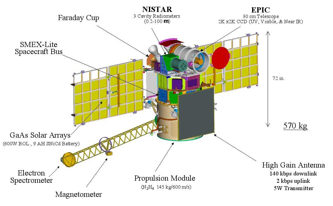
But the party piece of DSCOVR is the Earth Polychromatic Imaging Camera (EPIC), which is a 30 cm (11.8 in) telescope operating in the ultraviolet and visible spectrum. Its job is to take images of the sunlit side of the Earth to study weather, climate, and pollution. With a resolution between 25 and 35 km (14.5 to 21.7 mi), it is the first satellite capable of sending back a single high-resolution image of Earth instead of building one up from a mosaic of images.
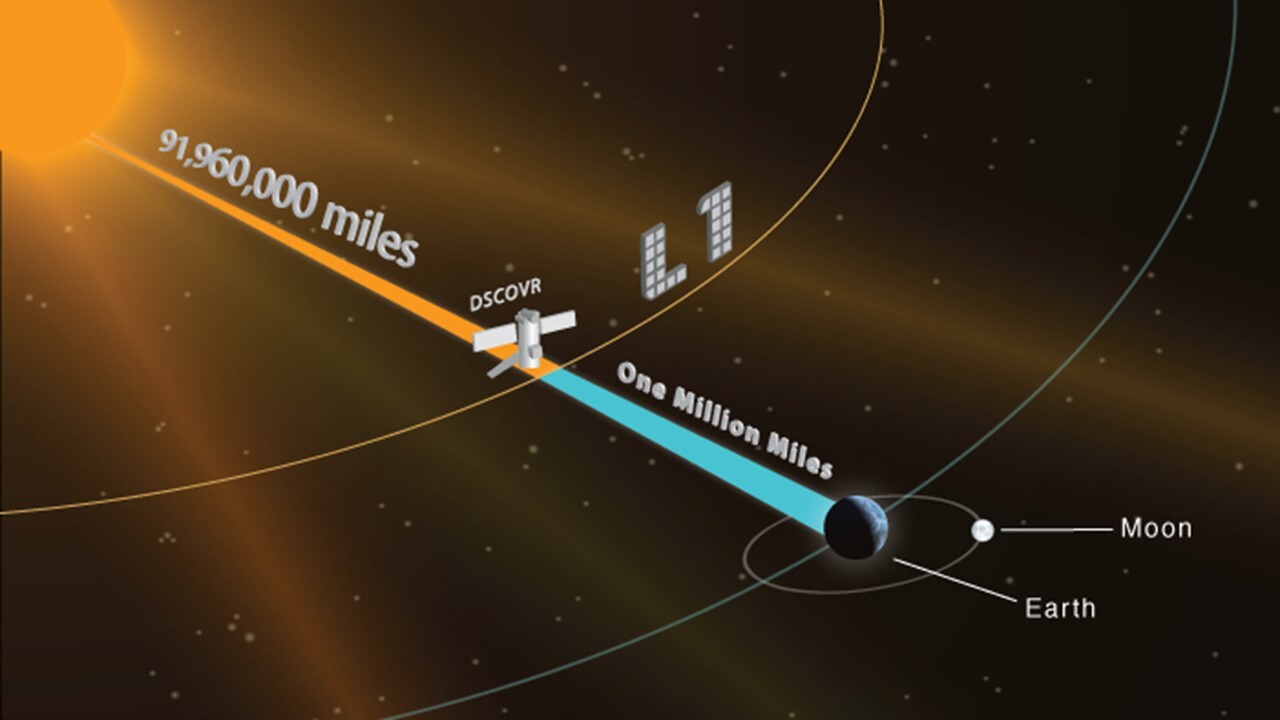
DSCOVR is scheduled to be launched atop a SpaceX Falcon 9 v 1.1 launch vehicle from Cape Canaveral on Monday. If successful, it will spend about 110 days traveling to its destination, which is the Sun-Earth Lagrangian point 1 (L1), 1.5 million km (930,000 mi) from Earth. This is the point between the Earth and the Sun where the gravitational forces balance out, so the satellite remains on station. It allows the satellite to always stay sunward of Earth at a distance that provides 45 to 30 minutes of warning, depending on the speed of the incoming solar particles.
The video below outlines the DSCOVR mission.
Source: NOAA
Update: DISCOVR was successfully launched on February 11, 2015 from Cape Canaveral at 6:03 EST.