Gold Country, California is a way to disconnect from online life in the modern world. I spent two days trying to tweet and make calls on my cellphone in Calaveras County and Tuolumne County northwest of Yosemite National Park in the Sierra Nevada foothills. Reception was spotty regardless of your cell phone provider. There was a group of us, locals and travel writers from different parts of California, passing around our cell phones when one or the other had reception and it was necessary to make contact. Much of everyone’s time was forcibly offline and out of touch with anything beyond the people and world in front of you.
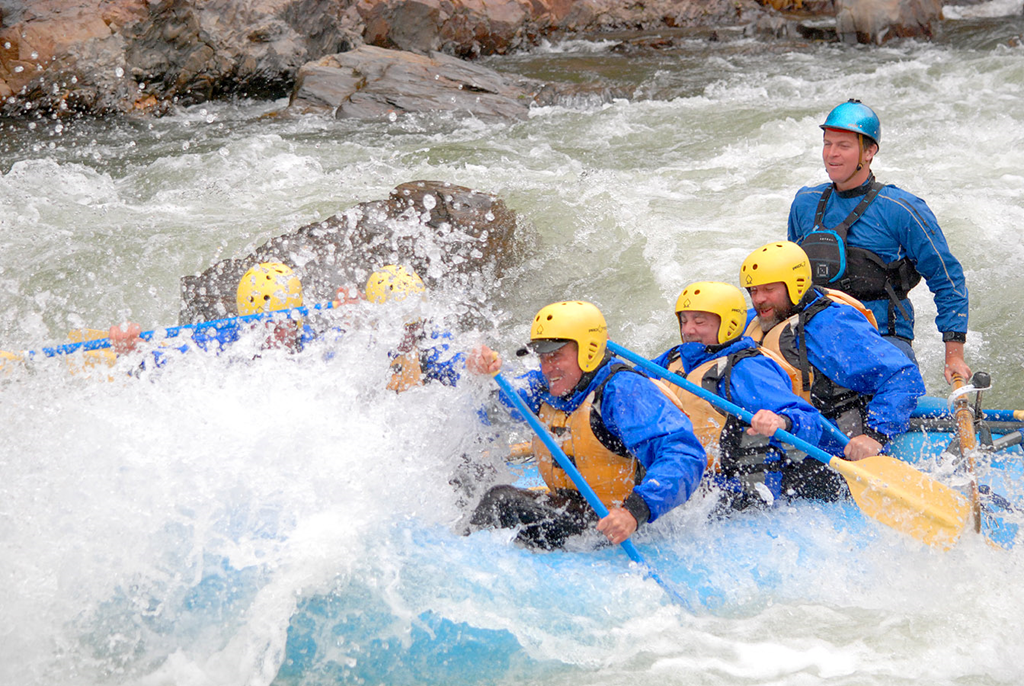
In touring the Gold Country, the realization soon took hold that the appearance of these old gold country towns was more than a façade. Wilderness still rules this part of California where 21st century technology is still not widely functional. On the third day of a travel writers’ sponsored trip, our group of five went on a Tuolumne River whitewater rafting trip, leaving behind our cell phones and cameras for an 8-hour adventure over 18 miles of Sierra Nevada water wilderness.
Tuolumne looks like a hard word to pronounce. A way to remember the pronunciation is the phrase, “Follow me to Tuolumne” or ‘Too-all-o-me’.
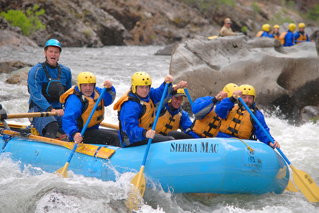
Sierra Mac is one of the few companies with permits for rafting the Tuolumne River. There is a limit of about 28 persons per day on the river. I am in foreground in front of river guide Tom McDonnell, son of Sierra Mac founder Marty McDonnell.
The drive from Sonora where we spent the night at Best Western Sonora took about an hour to reach the rafting center a few miles east of Groveland on Highway 120, the northern road into Yosemite National Park. The 8:30am departure from the rafting center pickup on Highway 120 down a steep mountain dirt road to the Tuolumne River in a van towing large rubber rafts was another 40 minutes. At the river it was about an hour for set-up, moving the rafts to the river, changing into wetsuits and river safety gear and receiving instruction on surviving Class IV rapids should you fall out of the raft. This meant it was around 10am before actually getting on water. With about an hour break from 1pm to 2pm for lunch on the riverbank, the excursion was six hours on the river. Sierra Mac also does two and three day tours starting farther upstream and Class V Upper Tuolumne Cherry Creek 8 mile runs.
Once on the river there is really no turning back. The ride is 18 miles through wilderness terrain and unless you have a helicopter, you are on the river for the duration.
I carried nothing but my car keys in a bag secured to the raft. My camera is not waterproof. Photos in this post are courtesy of Rapid Shooter www.picturethisimaginethat.biz who kayaked ahead of the raft and set up for photos at key points on the river.
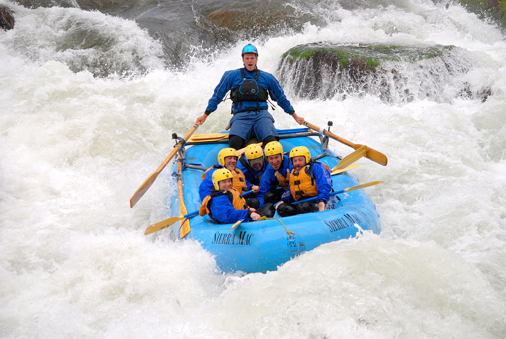
This rafting adventure on the Tuolumne River was exciting without being too frightening. The kind of whitewater action seen in this photo occurred in about a dozen locations along the route for about one hour of whitewater rapids in the six hour journey. This is just the hold on and don’t fall out portion of the trip. Nobody fell out of the raft. For those desiring more immersion in whitewater, the upper Tuolumne River offers Class V rapids.
In the raft there are minimal restraints to keep one inside the raft, aside from a foot holder like the front half of a clog for two feet if in front, but only one foot in the center section. I kept my other foot wedged under an inflatable center cylinder of the raft. My legs were sore after a day keeping them mostly stiff in the raft while on the water. I really did not want to fall out of the raft.
Expecting my arms and upper body to be the sorest section of my body, it turned out my legs were my jelly half after a day on the river. That surprised me.
Tuolumne River, California
The Tuolumne River is 149 miles in length. The source of the river is in Yosemite National Park at the confluence of the Dana and Lyell forks. May 2013, I drove Tioga Pass east to west through Yosemite National Park and spent some time around the Tuolumne River in Tuolumne Meadows.
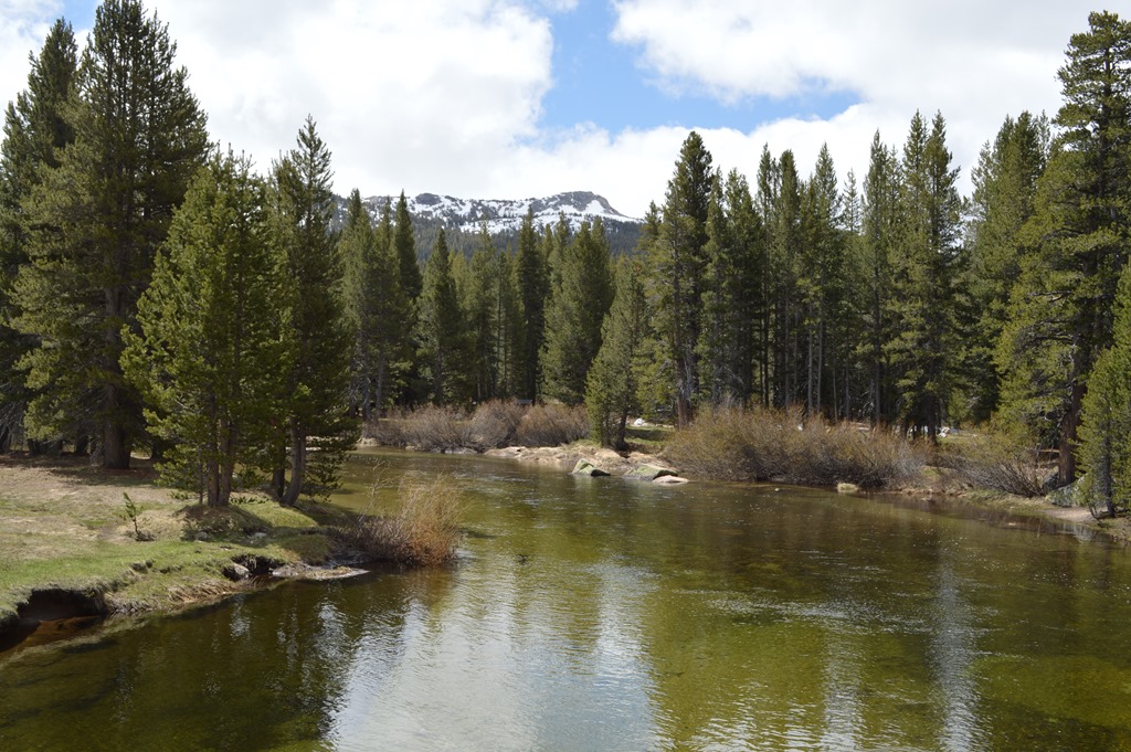
Tuolumne River in Tuolumne Meadows at about 8,600 feet in elevation in high Sierra of Yosemite National Park.
The Tuolumne River flows through valleys north of Yosemite Valley. Yosemite Valley is the Merced River.
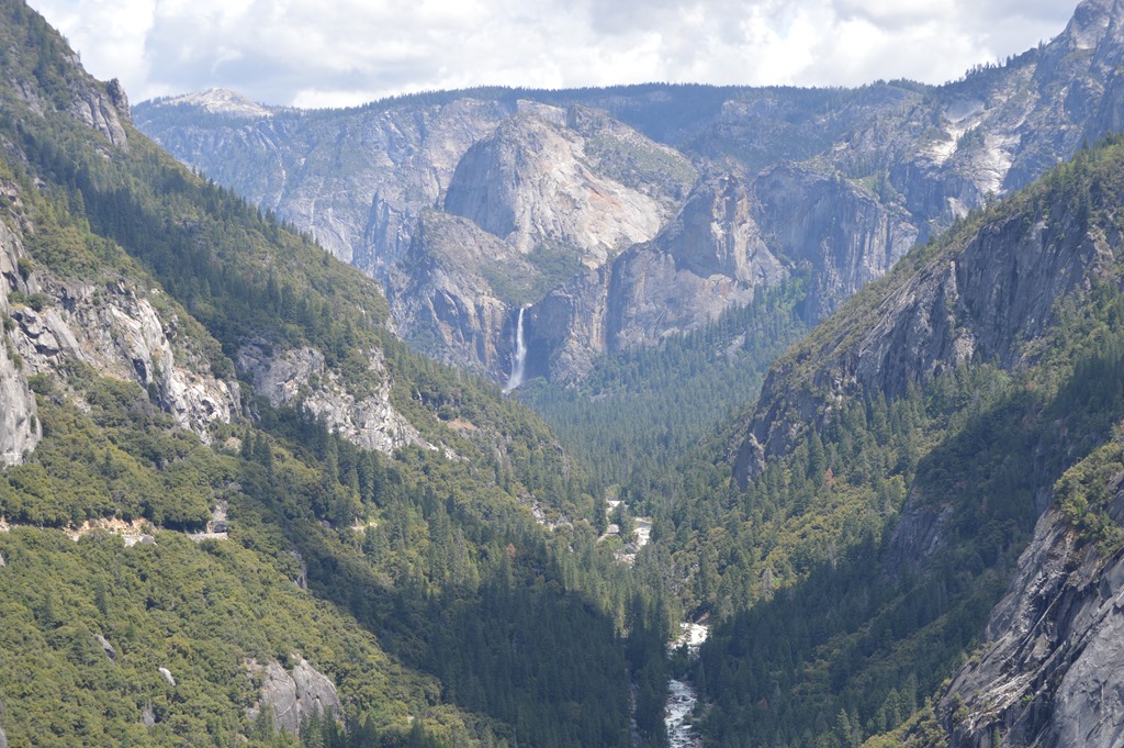
Yosemite Valley with Bridalveil Fall dropping 600 feet down into Merced River.
The great naturalist and environmentalist John Muir argued against the damming of the Tuolumne River at Hetch-Hetchy Valley in northern Yosemite National Park. There was a movement following the San Francisco earthquake of 1906 to create a cheap and reliable water supply for the San Francisco Bay area. Here is an excerpt from Muir’s January 1908 Sierra Club Bulletin article:
It is impossible to overestimate the value of wild mountains and mountain temples as places for people to grow in, recreation grounds for soul and body. They are the greatest of our natural resources, God’s best gifts, but none, however high and holy, is beyond reach of the spoiler. In these ravaging money-mad days monopolizing San Francisco capitalists are now doing their best to destroy the Yosemite Park, the most wonderful of all our great mountain national parks. Beginning on the Tuolumne side, they are trying with a lot of sinful ingenuity to get the Government’s permission to dam and destroy the Hetch-Hetchy Valley for a reservoir, simply that comparatively private gain may be made out of universal public loss, while of course the Sierra Club is doing all it can to save the valley. The Honorable Secretary of the Interior has not yet announced his decision in the case, but in all that has come and gone nothing discouraging is yet in sight on our side of the fight.
As long as the busy public in general knew little or nothing about the Hetch-Hetchy Valley, the few cunning drivers of the damming scheme, working in darkness like moles in a low-lying meadow, seemed confident of success; but when light was turned on and the truth became manifest that next to Yosemite, Hetch-Hetchy is the most wonderful and most important feature of the great park, that damming it would destroy it, render it inaccessible, and block the way through the wonderful Tuolumne Cañon to the grand central campground in the upper Tuolumne Valley, thousands from near and far came to our help, — mountaineers, nature-lovers, naturalists. Most of our thousand club members wrote to the President or Secretary protesting against the destructive reservoir scheme while other sources of city water as pure or purer than the Hetch-Hetchy were available; so also did the Oregon and Washington mountaineering clubs and the Appalachian of Boston and public-spirited citizens everywhere. And the President, recognizing the need of beauty as well as bread and water in the life of the nation, far from favoring the destruction of any of our country’s natural wonder parks and temples, is trying amid a host of other cares to save them all. Within a very short time he has saved the petrified forests of Arizona and the Grand Cañon, and in our own State the jagged peaks of San Benito county known as “The Pinnacles,” making them national monuments or parks to be preserved for the people forever. None, therefore, need doubt that everything possible will be done to save Hetch-Hetchy.
After my first visit, in the autumn of 1871, I have always called it the Tuolumne Yosemite, for it is a wonderfully exact counterpart of the great Yosemite, not only in its crystal river and sublime rocks and waterfalls, but in the gardens, groves, and meadows of its flower park-like floor. The floor of Yosemite is about 4,000 feet above the sea, the Hetch -Hetchy floor about 3,700; the walls of both are of gray granite, rise abruptly out of the flowery grass and groves are sculptured in the same style, and in both every rock is a glacial monument.
I encourage you to read the entire John Muir article for its description of Hetch-Hetchy Valley. San Francisco’s application to the Secretary of the Interior in 1908 was approved for water rights to the Tuolumne River. This led to a seven year battle to preserve Hetch-Hetchy Valley. Since the Tuolumne River and Hetch-Hetchy were in Yosemite National Park, it required an act of Congress to allow construction of a dam in the park land. That approval was granted with the Raker Act in 1913 and signed by President Woodrow Wilson.
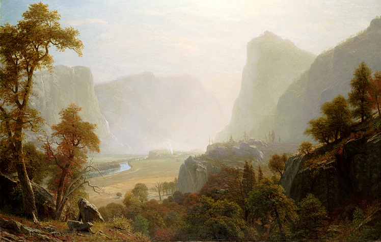
Albert Bierstadt – Hetch-Hetchy Valley from Road (1870)
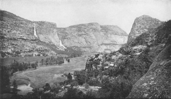
Hetch-Hetchy Valley photo from January 1908 Sierra Club Bulletin.
Work began on damming the Tuolumne River in 1914 and the O’Shaughnessy Dam was completed in 1923. Hetch-Hetchy Valley in Yosemite National Park today is a 300 ft. deep lake.
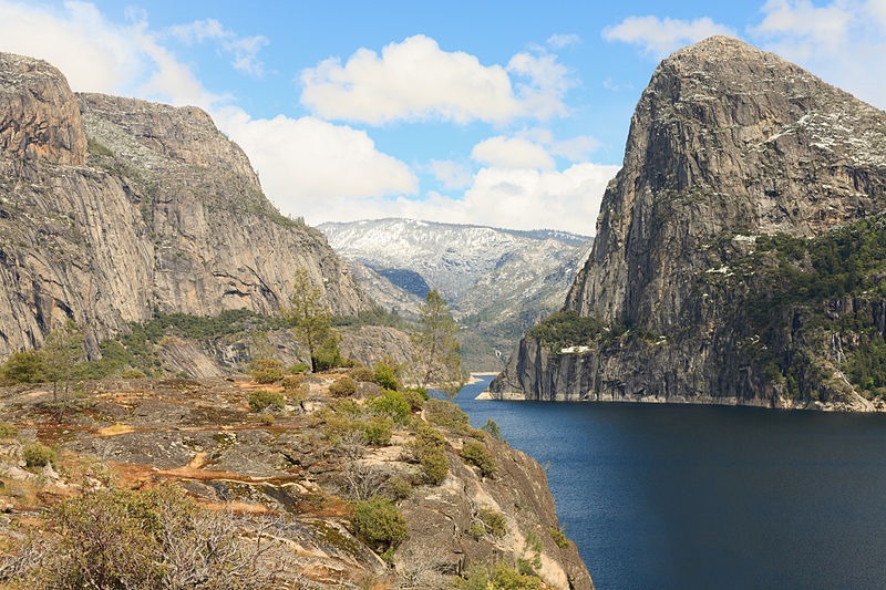
Hetch-Hetchy Reservoir May 2011.
The flow on the Tuolumne River where we rafted is controlled by release of water from Hetch-Hetchy Reservoir as needed for water and power generation. The flow decreases in the summer months and rafting trips on the lower Tuolumne River are dependent on the flow. Our guide Tom said that in summer trips with overnight camping there are times when the party needs to remain in camp until later in the day when the river fills with release water.
The Tuolumne River in 1984 was included in the National Wild and Scenic Rivers system with 54 miles of river within Yosemite National Park above Hetch-Hetchy Reservoir. The portion of river I rafted was the lower Tuolumne outside Yosemite National Park.
Rim Fire of 2013 was third largest wildfire in California history.
Much of the dinner table conversation after theriver rafting trip was about the Rim Fire started August 17, 2013. The fire had burned 180,000 acres in the first ten days to be the 7th largest wildfire in modern California history when I wrote an article on Loyalty Traveler. The Rim Fire moved to #3 on the list of California wildfires by the time the fire was fully contained. Marty McDonnell, owner of Sierra Mac River Trips, said the fire burned to within feet of his home and he was one of the last to evacuate as walls of flames were burning the forest. Remarkably, firefighters saved his home.
Evidence of the Rim Fire was visible for nearly all 18 miles of the Tuolumne River rafting trip. The mountain ridges revealed burned and blackened barren trees. On the other hand, the valley mountainsides showed remarkably quick recovery with lush deciduous trees, plenty of green undergrowth and many blackened, yet living and green trees.
Observing the hillsides of the Tuolumne River valley was an activity that happened when not riding Class IV rapids.
One of the beautiful sights came near the end of the river rafting day as we passed beneath a bald eagle’s nest with an eaglet visible on the tree branch above the nest.
This was actually my first time ever whitewater rafting. Tom McDonnell called out the stroke commands and I did my best to get the paddle in the water moving the correct direction.
This was one of the best adventures I have had in years.
Since 1965, we at Sierra Mac River Rafting Trips have dedicated ourselves to providing exceptionally fine whitewater river trips. We operate exclusively on California’s extraordinary Tuolumne River, one of the few rivers in the state bestowed with “Wild and Scenic” status by the US Congress for its outstanding whitewater and superb scenery. The Tuolumne’s classic class IV run from Meral’s Pool to Ward’s Ferry is excellent for first time boaters and veteran river runners alike. The Cherry Creek/Upper Tuolumne is for serious boaters looking for the ultimate challenge. Expert guides, state of the art self-bailing rafts, plentiful and delicious meals, and meticulous, behind-the-scenes planning is our hallmark. For the Tuolumne River, you won’t find a crew with more years on the water and better credentials than Sierra Mac.
Blogger Disclosure:
My Sierra Mac River Trip was provided free of charge as a travel writer invited to experience Calaveras and Tuolumne County on a familiarization trip May 18-21, 2014. The current price for this one-day river trip is $259 per individual. There are discount rates for 6+ and 12+ groups.
Besides being highly experienced river guides, the hours I spent talking with Marty McDonnell at dinner and his son Tom on the river gave me additional pleasure to meet people who have such passion and love for their work and the environment. This was a wilderness adventure I highly recommend.
*****
Ric Garrido of Monterey, California is writer and owner of Loyalty Traveler.
Loyalty Traveler shares news and views on hotels, hotel loyalty programs and vacation destinations for frequent guests.
Follow Loyalty Traveler on Twitter and Facebook and RSS feed.

2 Comments
Comments are closed.